About Red Eft Mapping
Regarding the name Red Eft Mapping :
The Red Eft, also known as the Red Spotted Newt, was my favorite creature on the A.T. They are found on the Appalachian Trail in all 14 A.T. states from Georgia to Maine, and invariably appear on the very worst of rainy days. Their cheery colors and docile temperament made many a dreary hiking day a brighter experience, and I rescued hundreds from being trampled by gently moving them off-trail by their tails.
Hopefully my maps will also give fans of the Appalachian Trail some good cheer for many years, just as the Red Eft did for me and countless other very wet A.T. hikers.
A bit of history :
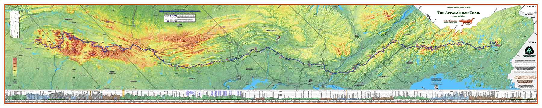
Red Eft Mapping began as a personal project of mine. I am an Appalachian Trail “2,000 miler” who has hiked the entirety of the A.T., and I wanted to create a beautiful wall-sized map for myself to remember my journey.
The term “2,000 miler” is a term the Appalachian Trail Conservancy uses to refer to a hiker who has hiked the entirety of the Trail, since mileage varies year to year. In my case, the official trail length for the years I hiked was 2,189.2 miles, all with full pack, no slackpacking, no blue-blazing, aqua-blazing, or yellow-blazing. My lips are sealed on blazing involving other colors. I passed each and every A.T. blaze with full pack, NoBo all the way. Call me a purist, but hike your own hike.
In 2015, in a sort of semi-retirement (or senior gap year?), and mental cleansing after a somewhat toxic volunteer experience, I decided to thru-hike the entirety of the Appalachian Trail. I hiked 1,375.3 miles that year from the southern terminus of the trail at Springer Mtn, GA to just over the New York state line, where a ligament in my foot said “no más!” and decided to rupture after stepping on a rock at Wildcat shelter. So, I had to step off the trail to let the foot heal until I could pick up again the next year.
My fellow hikers had bestowed the trail name ‘McGyver’ on me (the spelling I use has its own story, not to mention how I got the name and ultimately decided to take it).
My injured foot healed over the winter, and in the spring of 2016 I picked up right where I left off, and hiked the remaining 813.9 miles, summiting Katahdin in the summer of 2016. So, although not a pure “thru-hike”, I call it a “thru in two”.
In the time between those two hikes, which totaled 2,189.2 miles (2015 trail mileage), I helped David ‘AWOL’ Miller refine his elevation profiles for his famous A.T. Guide for the 2016 edition, and I have provided the A.T. Guide with freshly updated elevation profiles each year since then, continuing to the current 2022 edition.
With my many years of professional land surveying experience in the field, the computer programming I learned as a career electronics design engineer, and the experience in developing the yearly elevation profiles for the A.T. Guide, it was then that I decided that I wanted to create for myself a man-cave sized map of the Appalachian Trail to commemorate my hike. And so, this project was born.
Curiously, as life often turns out, although I have created many of these mural-sized custom maps for other hikers now, I still have not yet created my own personal map. Soon…
– McGyver