


Here you may order our fully customized Appalachian Trail map.
Like our standard maps, the map is 10 feet wide by 2 feet tall, designed to be mounted horizontally. It is printed on professional canvas with non-fade archival inks (but not designed to be mounted outdoors). The terrain detail on this map has to be seen to be fully appreciated. One of our recent customers, Steve Adams posted a video review of his custom on YouTube. You may view it here: https://www.youtube.com/watch?v=zs2XvoTHrkw
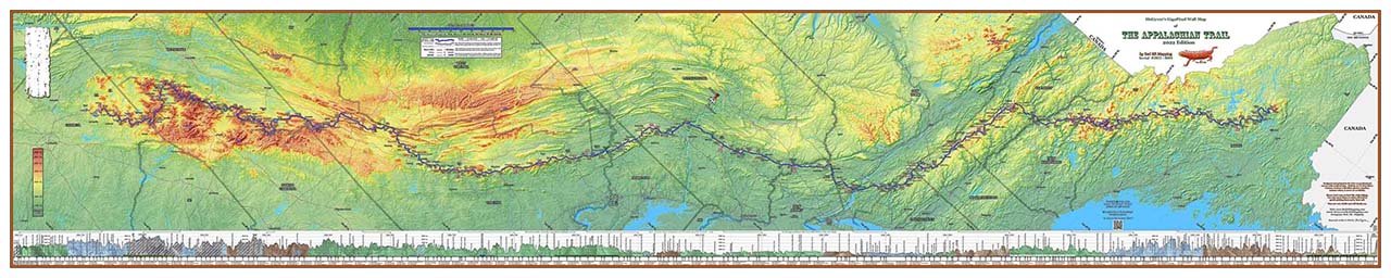
Your map will include the elevation profile of the entire trail, with hundreds of marked geographic locations. On the main field of the map you will also see the locations of all the official AT shelters.
Your customizations are up to you, and include, but are not limited to:
- Your choice of hypsometric coloring (elevation based background coloring) or having the states individually colored.
- You may choose the coloring of the states, and are welcome to give input on the color arrangement of the hypsometric coloring, depending upon which version you choose.
- We can include roughly 50 of your favorite AT trail photos on the full-width “PhotoBar” at the bottom of the map. Each photo will also be captioned.
- If you kept a trail journal, or have other means of reconstructing where you camped each night, or hiked each day, we will include a timeline of your hike just below the elevation profile. If you just have partial dates or locations, that’s OK – we will include as much or as little as you have.
- We will customize the title block of the map with your name, trail name, Springer and Katahdin summit dates, unique serial number, and anything else you may want there.
- If you had a favorite trail saying or mantra of significance to you, we have a space to include that also – just to the right of the timeline.
- If you like, we can put your summit (or other) photo as the background in the title block.
- Assuming that we have data for the year of your hike, we will make all of the mileages on the trail, geographic landmarks, and elevation profile conform to your hike year.
- If you can dream up anything else, we are happy to do it to make your map as personal and cool as possible!
- We will do any or ALL of these customizations for the same price of $325.00, at least until we come to our senses and double the price!
Obviously, we cannot build a web form to put in all of your options, as they are infinite! So, just order here, and we will contact you promptly with how to get the process rolling! If you have any questions beforehand, feel free to email us at [email protected]
Move the mouse in the image to see more detail, or click on the magnifying glass to see a larger image.